
(2014)

3-dimensional view of major Southern California faults. Vertical faults like the San Andreas are pencil thin lines, those at an angle to the surface are broad brush strokes. (Taken from the highly recommended site earthquakecountry.org.)
That Puente Hills fault that caused the quake out in Brea yesterday (in 2014) is the one that terrifies geologists. They used to think the Elysian Park fault was the killer–our house sits right atop that one–but it now appears to be dormant. But in the last ten thousand years the Puente Hills fault has snapped in a huge way four times, and each of those quakes was a 7 plus on the Richter scale. That would be ten times at least as powerful as the 1994 Northridge quake. Furthermore, the Northridge fault directed its energy away from downtown (with explains how places as far away as Fillmore were leveled) but the Puente Hills fault would direct its energy towards downtown. I suppose that is how people in downtown last night felt the shaking of a quake centered in Brea so strongly (and why we scarcely noticed while we were out in Tujunga). The Puente Hills fault stretches from roughly Brea to Beverly Hills, and it has three active areas–Brea, Whittier (remember the Whittier Narrows quake in 1987?) and here. And I mean right here…downtown Los Angeles is square in the middle of it, and the zone’s width goes from just below USC to about where I am in Silver Lake. In fact, being that I am typing this while literally astride the Elysian Park fault, our place is just outside the Puente Hills fault zone, not that we wouldn’t shake like hell anyway. We wouldn’t shake as bad as people on the nearby flatlands, their homes built as they are on layers of sediments, but we’ll be shook up something awful. I dread the thought of it. It won’t be boring, anyway. (There was another shaker on the Puente Hills Fault in January 2015 that got everyone’s attention just a few blocks from us but that we literally did not feel at all. Not even the cat noticed.)
The Puente Hills fault is a thrust fault. Everyone knows how the San Andreas fault (which cuts through the Antelope Valley down into the Coachella Valley fairly distant from us) is between two plates that slide past one another. Every once in a while the plates get stuck and then snap apart. The movement is horizontal. West of the fault goes north, east goes south. But a thrust fault is vertical movement, that is the fault zone is thrust upward. As the tectonic plates move, pressures build up in the rock beneath us. Stress fractures appear, which we call faults. Those pressures reach a point where something has to give and when they do, you get an earthquake along one of those stress fractures. Most of the times these quakes are imperceptible to anything but a seismograph machine. Sometimes they are strong enough to wake the cat. Sometimes they are strong enough to set off a flurry of chatter on Facebook. And sometimes they are bigger than that. In a really big quake along the Puente Hills fault zone, the ground will suddenly lurch up a meter or two, meaning that the part of town from USC up through downtown will be instantly elevated above the area south of it. Think of it this way: all the north south streets–Alameda, Hope, Flower, Figueroa, Hoover, Vermont, etc.–would suddenly be unusable, because at some point past Exposition Boulevard there would be a three or even six foot drop straight down. Not gradual, not sloping, but straight down. You will need a ladder to proceed down the sidewalk. That is what huge quakes on thrust faults do.
No one knows when this will happen. It will happen. There is no way it will not happen. But it could be before I finish this post, or it could be in a couple thousand years. Every city on the West Coast from Anchorage (trashed in 1964) to San Diego (my first earthquake memory) faces the prospect of a disastrous earthquake. That is the geologic reality of living on the Pacific Rim. It’s scary as hell if you think about it much, so I don’t think about it much. We try to be a little prepared, though. Just in case. Ya never know.
I wasn’t going to post this. Like maybe it’s too creepy. But maybe people should know. A lot of you do already. But it’s amazing how many residents of this area have no idea what might happen if we roll seismic snake eyes.
Now I need a drink.
And you will too, after seeing this Visualization of a Puente Hills Earthquake. It is in real time, and the color key represents the degree of shaking. Blue is the least violent, green more so, yellow even more and on into the red. You notice that the more intense shaking–the greener, yellower and even red colors, are in the flatlands between downtown and the Palos Verdes Peninsula. The sediments of the basin there are up to six miles deep, laid down mostly when the land was ocean bottom and compressed into the easily crumbled rock that you see in some roadcuts. But the meandering Los Angeles River has over thousands and thousands of years left deep, sandy soils that once made for terrific farmland and now are really prone to intense liquefaction when the ground shakes. There was intense damage in this area after the Northridge quake, probably all of which was caused by liquefaction. The ground under overpasses on the Santa Monica Freeway lost its solidity and the poor things just toppled. That’s an impressive sight, and immense concrete bridge in pieces on the ground. That was the destructive power of liquefaction. And that epicenter was much further away than this hypothetical Puente Hills quake would be. The damage from a 7 magnitude quake in the Downtown area would be exponentially greater. A lot more overpasses would topple. A lot of houses will be red tagged. What a mess.
Probably be some great yard sales, though.
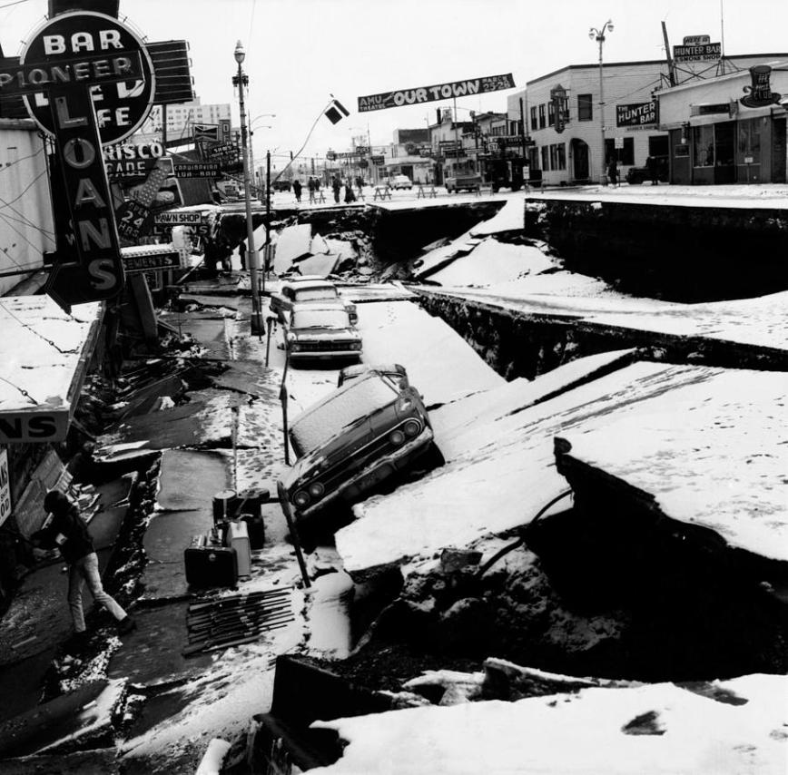
Anchorage, 1964. You’ll be happy to know that no matter how nasty a quake the San Andreas has in store for Southern California, this sort of thing will not happen. The Anchorage quake was one vast tectonic plate (the Pacific) suddenly shoving itself beneath another (the North American plate). Subduction they call it, a slow process that every once in a while gets stuck. When subduction unsticks you get scenes like this. The North American plate side of 4th Street here wound up 38 feet above the Pacific plate side, making parking difficult. This cannot happen on the San Andreas, which is where the same two plates just slide past each other, one heading north, once south. Occasionally things get stuck and then, after some time, unstuck. It was the unstuck that leveled San Francisco in 1906. And it will be a similar unsticking that will someday level Palmdale and Palm Springs, shaking the rest of us something awful. However, there would be no displacement like that in Anchorage–the San Andreas unsticking would be a sudden horizontal movement, not vertical. If that makes you feel any better.
